Quay or Pier: Two Different Ways to Meet the Water
Learn how to tell a quay from a pier on a harbour visit by reading its shoreline, supports, working edges and connections to the land.
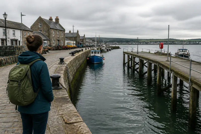
A quay usually holds the edge of the land; a pier reaches out from it. On a harbour visit, that simple difference is the quickest clue to whether a structure is primarily making space beside the shore or extending access over the water. Quay or pier is not always an obvious choice: names vary, and harbours often combine both forms. Look at how each structure meets land and water before relying on its sign or local name.
Start by tracing the structure’s connection to shore
Stand where you can see the structure’s landward end and its water-facing sides. A quay commonly runs along the shore, with water on one side and buildings, roads or reclaimed ground behind it. Its face acts as a retaining edge: it supports land on one side while providing a place for vessels to lie alongside on the other.
A pier, by contrast, projects into the water. Water can usually be seen on both sides of at least part of it, and the structure has a distinct route back to shore. It may end in a broad platform, a narrow landing or another working area. The shape is a clue, not a verdict: a quay can bend around a basin, while a pier may be joined to a larger harbour complex.
Use a harbour map, if one is available, to check the outline. A long edge following the coastline is likely to be a quay; a finger-like structure jutting into a basin or bay is more likely to be a pier. On a compact waterfront, the two may connect, so identify each section by its form rather than assigning one label to the whole site.
Read the working face and the space behind it
Look at what happens at the water’s edge. A quay often has a continuous or near-continuous wall, sometimes with a flat coping along the top. The harbour side may show rubbing strips, fenders, ladders, bollards or mooring rings. These fittings help vessels lie alongside or give people access between deck and shore. A broad apron behind the edge can provide room for handling cargo, storing gear or moving along the waterfront.
A pier may have a more open underside. From a safe public viewpoint, you might see piles or other supports beneath its deck, with water between them. Its deck can carry a walkway, mooring points or a small landing rather than a wide strip of ground behind a retaining wall. Some piers are solid throughout, though; a filled pier can look more like a quay when seen from above.
Ask what the structure makes possible. Does it create a usable edge beside land, or does it carry people and vessels farther over water? That question is more reliable than the presence of any single fitting. Bollards can appear on both, and a promenade or fishing spot does not by itself settle the name.
Follow the vessel’s route to the structure
Notice where a boat would approach and lie. Along a quay, a vessel generally comes alongside the harbour edge, parallel or nearly parallel to it. Several vessels may use different stretches of the same face, depending on the layout and harbour activity. The shore-side apron offers a direct connection from boat to land.
At a pier, a vessel may berth against one or both projecting sides, or come to a landing at its outer end. The projection brings the landing point out to water that may be deeper or more accessible than the immediate shoreline. On a small harbour pier, the main function might be access for local boats; elsewhere, the structure may be a public walkway or a place to board a ferry. Form tells you how it meets the water, but fittings and use offer clues to its role.
Imagine you arrive at a harbour where a stone edge continues behind a row of warehouses, while a narrower deck extends from it into the basin on visible supports. The continuous edge is functioning as a quay: it retains the waterfront and lets vessels lie beside the land. The projecting deck is functioning as a pier: it carries access over the water, even if it joins the quay at its base.
Check the fittings without treating them as labels
Read equipment as evidence of use rather than a naming system. A quay used for freight may have a wide working surface, robust mooring fittings and access to storage or transport routes. A pier used for passenger access may have a defined landing, a gangway connection or signs directing people towards a boarding point. A fishing pier may have railings, lights or places to sit, while retaining a form that projects into the water.
Look for repeated clues. A single ladder could serve maintenance or emergency access; a line of ladders beside mooring fittings suggests regular access along the edge. A broad open apron behind a wall may point to handling and movement on land. A deck over water with a clear path to its end suggests that reaching beyond the shore is central to the structure.
It is not worth trying to identify every structure from a photo of one corner or one bollard. Take in the whole outline first, then use fittings to refine your reading. If the harbour has an information board or a map, compare its labels with the visible shape; local names can preserve usage that the structure’s current appearance does not reveal.
Quay or pier questions that help on a harbour visit?
Can a pier be solid rather than raised on piles?
Yes. Some piers are built as solid projections, so you may not see water beneath the deck. Follow the structure’s outline: if it extends away from the shore with water alongside, it can still function as a pier.
Can a quay curve around a harbour basin?
Yes. A quay can turn around a basin or harbour corner while continuing to hold the land edge. Its defining role is the usable waterfront face, not a perfectly straight plan.
Are all piers open to the public?
No. A pier can serve harbour operations, transport or private use, and access may be restricted. Follow signs and barriers, and observe from public areas rather than crossing a closed gate.
Why does one harbour use a different name?
Harbour names reflect local convention and the history of the place as well as visible form. Treat the label as useful local information, then describe what you can observe: whether the structure follows the shore or projects into the water.
Finish with a simple field note
Before leaving, make a short note that separates what you saw from what you infer. For example: “Stone wall follows the basin; boats lie alongside; broad apron behind it” describes a quay-like role. “Deck projects from shore; water on both sides; landing at the far end” records a pier-like form. This wording stays useful even if the local name differs.
On your next harbour visit, begin with the outline, inspect the water-facing edge, then look at the fittings and likely vessel route. That sequence gives you a sound basis for distinguishing a quay from a pier without mistaking one sign, one material or one mooring point for the whole story.